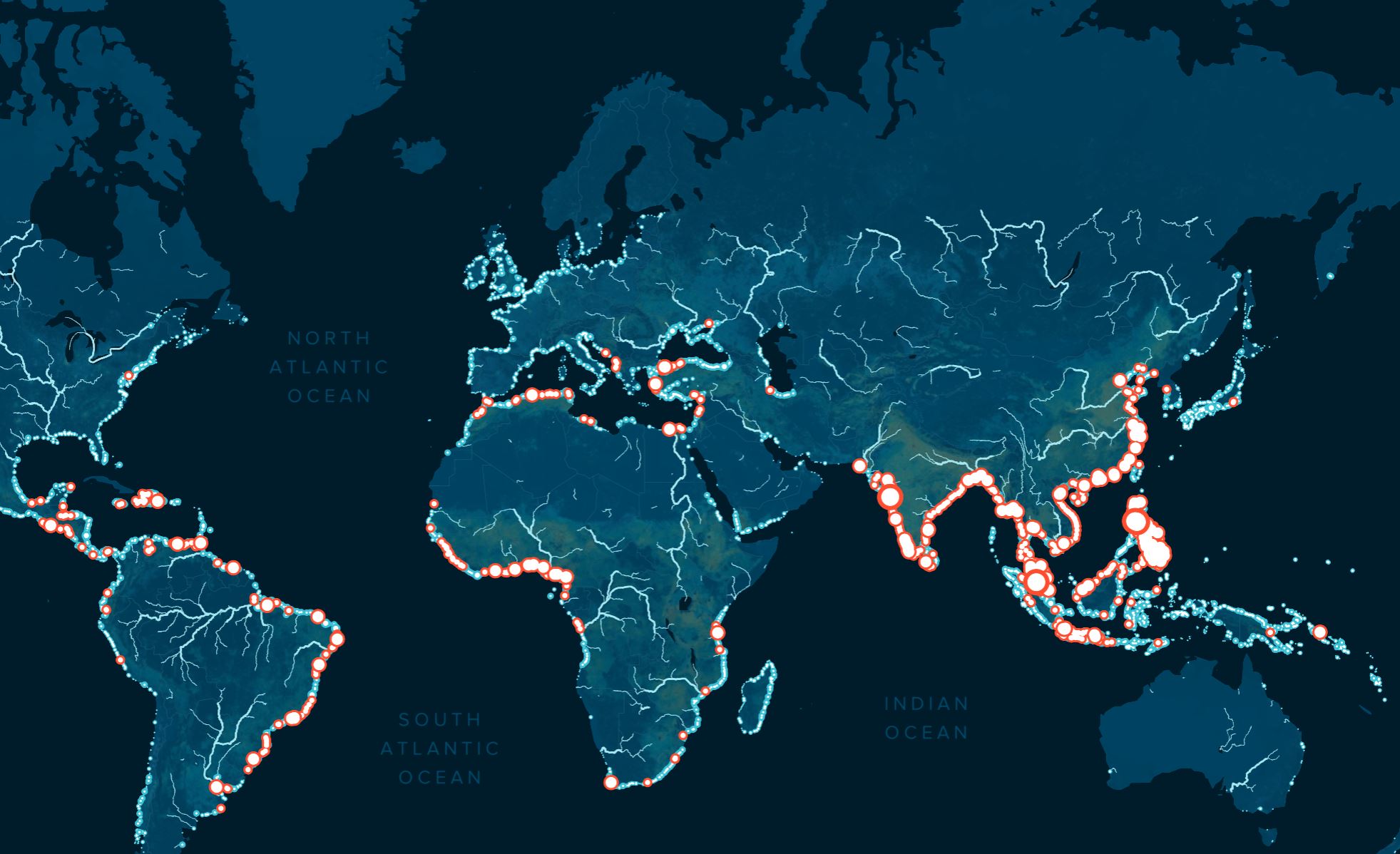
For the first time, we have a high-resolution, empirically grounded answer to a question that has long frustrated ocean science and policy: which rivers are doing the most harm, and how many do we need to fix? Our study, published in *Science Advances*, pinpoints 1,000 rivers, just one percent of the global total, as the source of nearly 80 percent of all riverine plastic entering the ocean. This is a measurable, validated target, and it changes the calculus of intervention entirely. The finding that small and medium-sized urban rivers, not just the mega-systems like the Yangtze or Ganges, dominate the emissions means that no single technology or policy will suffice. A range of calibrated, location-specific solutions is required, and that is precisely the kind of integrated approach our mission demands.
This result stands in sharp contrast to earlier models that suggested a handful of large rivers carried the burden. Those estimates were based on basin-level waste generation and a simple correction factor; they lacked the empirical data on actual transport dynamics. By incorporating 136 field measurements from 67 rivers across 14 countries and three continents, and by modeling the role of rainfall, wind, terrain slope, and land use, we have built a far more realistic picture. The model reveals that the plastic journey is non-linear, a chaotic cycle of stranding and remobilization, and that proximity to a river and the size of the river itself are critical variables. This is not an academic exercise. The interactive map we have released allows any organization, municipality, or policymaker to identify their nearest polluting river and begin planning mitigation. As we noted in our related coverage, Tracing plastic from 1,000 rivers to nearly 80% of ocean emissions provides a direct visual of these hotspots, while From coast to current: tracking plastic pollution through integrated ocean intelligence shows how such data feeds into broader ocean monitoring systems.
What does this mean in practical terms? It means the problem is solvable. One thousand rivers is a finite, addressable number, and our Interceptor technology is already deployed in some of these locations. But the data also forces a hard conversation about equity and infrastructure. Many of the most polluting rivers are in rapidly urbanizing areas where waste management systems have not kept pace with population growth. Mitigation cannot be a one-size-fits-all solution; it must range from floating booms and interceptors in canals to upstream policy changes in waste collection and consumer behavior. The model also carries important caveats: it estimates annual emissions between 0.8 and 2.7 million metric tons, and individual river loads may vary due to seasonality, extreme weather events, or existing cleanup efforts. Future work must incorporate higher temporal resolution to capture these fluctuations. The specific question we now face is not whether we can act, but whether we will coordinate globally to deploy the right mix of technologies and policies across these 1,000 rivers before the next ton of plastic reaches the sea.