data visualization
25 stories filed under data visualization on World Data Ocean. The newest of them: “2025 Global Temperature Data Confirms Measurable Warming Trends”, “From two million to over 450 million tonnes: measuring the rise of plastic production”, and “Tracking 350 million tons of annual plastic waste to its ocean sink”. The 2025 global temperature data from Berkeley Earth confirms what empirical climate indicators have long signaled: warming trends are measurable and persistent. From two million to over 450 million tonnes in seventy years, that is the measurable, empirical trajectory of global plastic production. A Global Hub for Ocean Intelligence 4 World Data Ocean is a centralized digital platform where researchers, scientists, and ocean enthusiasts converge to… The list below is every data visualization story on World Data Ocean, newest first.
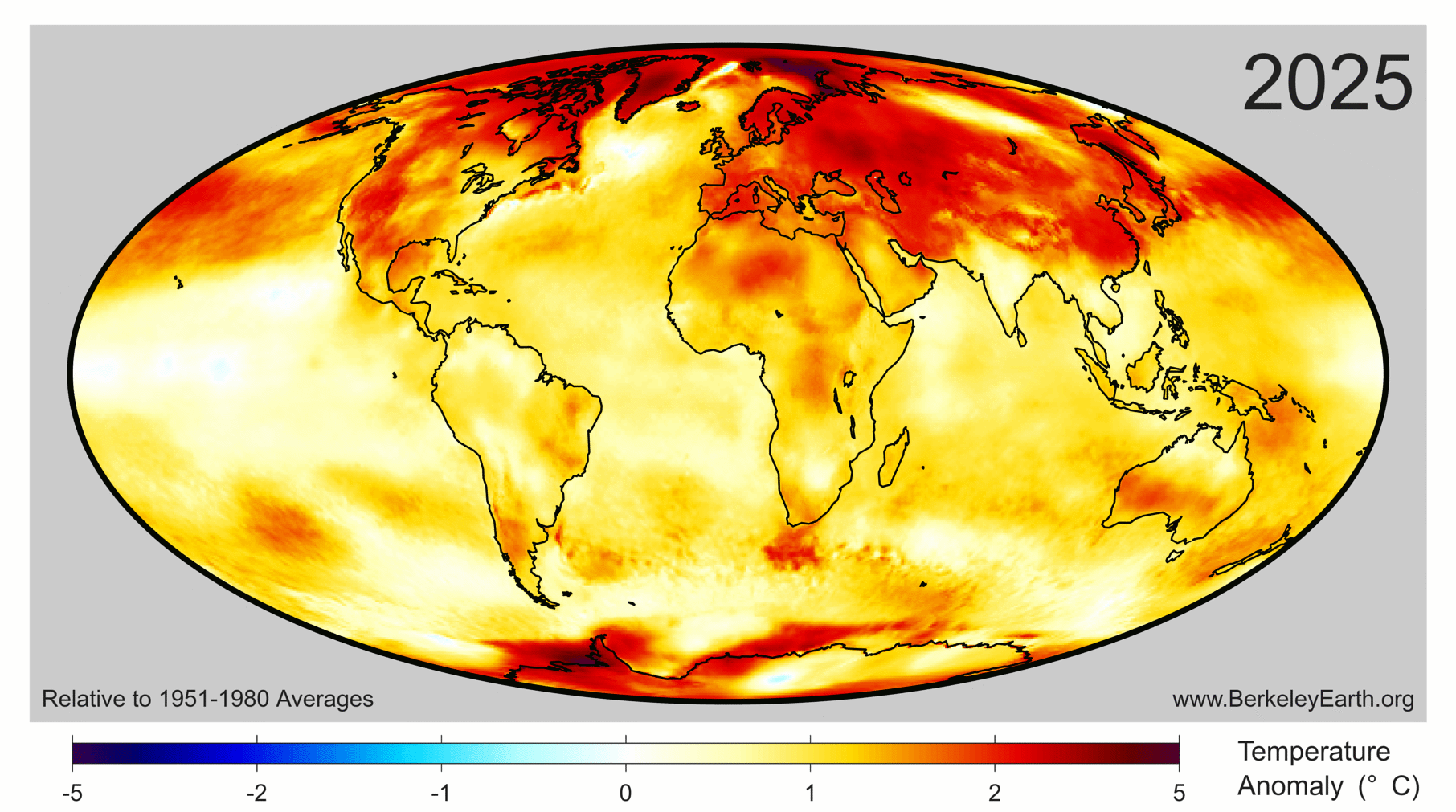
2025 Global Temperature Data Confirms Measurable Warming Trends
The 2025 global temperature data from Berkeley Earth confirms what empirical climate indicators have long signaled: warming trends are measurable and persistent. Since 2013, this independent non-profit has provided validated, peer-reviewed analyses of mean temperature changes. The findings are clear, and they demand purposeful attention. Understanding drives protection, and for deeper context on related pressures facing our oceans, see our piece "From waste to wave: measuring ocean plastic's true share."
From two million to over 450 million tonnes: measuring the rise of plastic production
From two million to over 450 million tonnes in seventy years, that is the measurable, empirical trajectory of global plastic production. This sharp rise demands calibrated observation, not alarm. Understanding the scale of this material shift is the first step toward integrated ocean intelligence. For deeper context on how we track such environmental changes, our piece *"From orbit to shore: sharpening coastal views through harmonized sensors"* explores the satellite technology making these measurements possible.
Tracking 350 million tons of annual plastic waste to its ocean sink
350 million tonnes of plastic waste enters the global system each year, but where does it finally settle? Tracking this debris to its ocean sink requires calibrated, real-time data, the kind of integrated ocean intelligence that reveals the measurable impact of human activity. Understanding this pathway is protection in action. For deeper context on how we validate such environmental signals, see our related coverage of measured sea level rise validated across decades of ocean data.
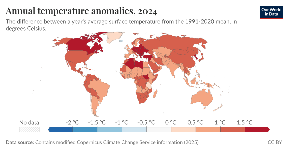
2025 Temperature Anomalies Reveal a Measurable Climate Signal
The 2025 temperature anomalies present a measurable, validated climate signal, not a speculative projection. These annual readings offer empirical evidence of systemic change, reinforcing the urgency of integrated ocean intelligence. Understanding drives protection, and this data sharpens our focus. For deeper context on how warming oceans reshape global systems, see our related coverage on seismic data revealing intensifying wave energy. These findings demand a shared, collaborative response grounded in scientific integrity.
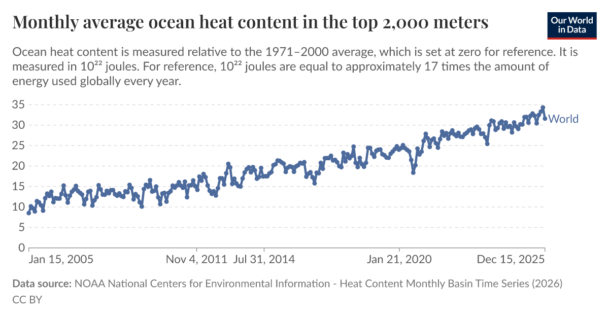
Measuring the Ocean's Warming Pulse at 2,000 Meters
Two thousand meters down, the ocean is warming measurably and without pause. Monthly average heat content in the top 2,000 meters provides one of the most empirically grounded climate indicators available, validated, peer-reviewed, and increasingly urgent. This isn't a distant signal; it is a calibrated pulse we can track in real time. Understanding drives protection. For deeper context on how global experts are building the data framework to monitor these changes, see "Global experts unite to steer Ocean Decade's data and knowledge framework."

Open Source Data Charts a Measurable Course for Global Ocean Mapping
A new open-source data framework charts a measurable course for global ocean mapping, turning fragmented observations into a coherent, integrated data ecosystem. This isn't abstract theory, it's a calibrated, peer-reviewed foundation for action. We see this as essential to building ocean intelligence. For a deeper look at how empirical data traces pollution back to its sources, see our related piece, "Tracing ocean plastic to its land-based sources via empirical data." Understanding drives protection.
Interactive Mapping Reveals Ocean Impacts from Physicochemical Shifts
Interactive mapping is exactly the kind of tool that turns raw physicochemical data into actionable ocean intelligence. By layering measurable shifts in temperature, salinity, or oxygen against biological responses, you're giving users a direct window into cause and effect. For a non-programmer, platforms like QGIS with the Leaflet plugin, or even CARTO, offer relatively gentle entry points. For deeper comparisons, Python's Plotly is worth the learning curve.

2025 Temperature Anomalies: Tracking Global Climate Indicators.
The 2025 temperature anomaly data from Our World in Data offers a measurable look at how far the climate has shifted. These annual figures are more than numbers; they are calibrated indicators of a planet in motion. We track them because understanding drives protection. The record ice gain in East Antarctica, detailed in our related coverage, reminds us that regional extremes can temporarily mask global trends. For now, the anomalies demand our attention, not alarm.

Digital Twin Reveals Vulnerable Atoll, Enabling Ocean Monitoring
Remote coral atolls like Oeno remain critically under-observed, not because they lack importance, but because isolation makes traditional surveys nearly impossible. This digital twin changes that. By integrating satellite imagery, drone data, and acoustic bathymetry into a single calibrated framework, the team has produced the first high-resolution representation of the atoll's lagoon, benthic habitats, and terrestrial structure. It is a practical, scalable model for monitoring shoreline evolution and coral bleaching, and a clear demonstration that integrated geospatial data can close observation gaps elsewhere.
Empowering Ocean Insights: Global Fishing Watch Data Now in ArcGIS.
Global Fishing Watch data is now live in ArcGIS Online and the Living Atlas, bringing validated, real-time ocean intelligence directly into the hands of researchers and policymakers. This integration is a practical step toward measurable stewardship, and we're glad to see it. For those tracking enforcement efforts, our related piece on Maritime Interdictions shows how such tools support security at sea. Understanding drives protection, and this data ecosystem makes that understanding more accessible than ever.
Modeling Reef Fish Habitat to Guide Marine Protection in Remote Islands
The Azores' expanding MPA network appears to be placed where it matters most, yet its no-take zones protect only a sliver of the high-suitability habitat these models identify. That distinction matters. Using a decade of underwater census data, the random forest approach turns sparse observations into actionable ocean intelligence, showing that lenient regulations may undercut legal protection. Spatial expansion alone won't close the gap; stricter enforcement will.
Optimized Image Filtering Streamlines Underwater Seabed Mapping
Underwater robots capture thousands of overlapping images during seabed surveys, but most of that visual data is redundant. This methodology filters out the noise, decoding and rectifying images before discarding those that add nothing new. The result is a 49.91% reduction in image load and a 30% faster processing time, all while keeping feature persistence above 0.97. That is efficient, measurable, and practical. For those interested in how we scale ocean observation, our piece on integrating citizen science offers a complementary view.
Unlock Ocean Insights: Explore the Data Platform Academy Demo.
The Academy Demo turns raw data into a working tool, showing how integrated, real-time feeds become something you can act on. We built it for clarity, not spectacle. The interface rewards curiosity, letting you trace a single signal from satellite to sea surface without losing the thread. It is a practical step toward broader ocean intelligence, and we hope it makes the case for open, peer-reviewed access.
Deep-Sea Fish Monitoring: Integrating eDNA and Visual Surveys for Conservation
Two surveys at Ritto Seamount, spanning 2020 and 2024, reveal that eDNA and visual tools see different facets of the same deep-sea community. Overlap was strikingly low, just 7.7% in shallow waters and 1.4% in the deep, reinforcing that single-method assessments miss the full picture. Combining approaches measurably raised species richness, yet detection gaps persist, likely tied to currents and eDNA shedding rates. Understanding these limitations sharpens our ocean intelligence.
eDNA Analysis Uncovers Whale Foraging Habits and Trophic Connections
Deep-diving sperm whales are hard to study, especially when they feed beyond human sight. New eDNA metabarcoding off Northern Norway's coast reveals that herring and capelin dominate the water column in March, likely drawing larger prey like cod and redfish to the whales' foraging depths. The method offers a non-invasive lens into trophic connections that dive tags alone cannot show. It is a practical step toward understanding how ocean ecosystems hold together.
Living Coral Reefs Rediscovered Off Benin’s Coast: A Significant Finding
For decades, the coral reefs mapped off Benin's coast in the 1960s were written off as lost. New surveys between April and December 2025 prove otherwise. Using sonar and underwater video, researchers have confirmed living mesophotic coral communities at 54 meters depth, dominated by octocorals and black corals. This is the first verified evidence of such ecosystems on the Gulf of Guinea shelf. It is a reminder that our assumptions about marine habitats demand empirical re-evaluation.
Predicting Coral Resilience: Scaling Reef Monitoring with Integrated Data.
Coral reef monitoring is scaling up, but only if the data can keep pace. NASA and NOAA's PICOGRAM framework tackles this head-on, using a promptable, image-only model to automate colony detection and percent-cover estimation. It achieves an 87.5% in-domain IoU and, crucially, a calibrated confidence score that lets managers set their own thresholds. This reduces the manual annotation burden without sacrificing accuracy.

Harpoon Launchers Bolster Ukraine's Defense Capabilities in the Black Sea
Ukraine has confirmed the deployment of a US-supplied Harpoon missile launcher, utilized for the first time against Russian naval targets in the Black Sea. This development was showcased during President Zelenskyy’s recent visit to Odesa. The validated use of this advanced weapon system underscores the ongoing escalation of maritime conflict. This action follows a pattern of increasingly sophisticated military aid provided to Ukraine. For further context on maritime security challenges, read our report on the release of seafarers held by Somali pirates.

Automated Welding Advances China's Offshore Oil & Gas Capabilities
China has significantly advanced its maritime capabilities with the deployment of its first indigenously built robotic welding system for offshore oil and gas rigs. Located in Tianjin, this AI-driven system represents a notable innovation in automating complex marine operations, increasing efficiency and safety in a critical sector. This development underscores China’s commitment to technological leadership in the energy industry, mirroring global trends toward automated solutions.

Iranian Defense System Intercepts Drone Near Key Shipping Lane
Iran has announced the successful interception of a "hostile drone" over the Persian Gulf, utilizing its new Arash-e Kamangir defense system. This incident occurred near Qeshm Island, a strategic location adjacent to crucial oil shipping routes. The development highlights Iran's ongoing efforts to enhance its military capabilities in a region marked by geopolitical tensions. For further insights into advancements in maritime technology, explore our article, "Hyperion Systems Unveils Southern Hemisphere’s First 3D-Printed Uncrewed Surface Vessel," which details innovative approaches in naval defense.

Modular Battery Swapping Vessel Demonstrates Ocean Logistics Innovation
The Hefu Weilan 01 has made history as the world's first standard modular battery-swapping ship, embarking on its maiden journey from Wuhu Port with 49 standard containers. This innovative vessel represents a significant advancement in sustainable maritime transport, demonstrating China's commitment to integrating cutting-edge technology in shipping operations. As the global maritime industry seeks to enhance efficiency and reduce emissions, the Hefu Weilan 01 sets a precedent for future developments. For further insights, explore our related article, "India Launches $1.
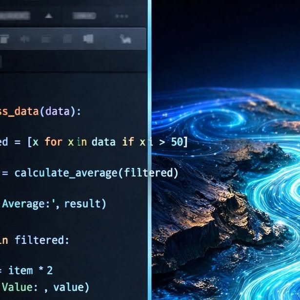
Unlock Ocean Insights: Efficient Data Access for Accelerated Research
Navigating the vast sea of raw data can feel overwhelming, but the Ocean Data Platform SDK is here to help you streamline your research process. Designed for efficiency, it allows you to filter and query data effectively, enabling you to focus on the insights that drive impactful ocean research. Coupled with our Python-based oceanography training, you will transform raw numbers into visual representations of ocean dynamics.

Mapping the Deep: Unveiling a Mediterranean Shipwreck Through Precision Imaging
The Precision ROV, deployed by CEPHISMER with scientific support from DRASSM, has successfully captured 86,000 images of one of the Mediterranean's deepest shipwrecks. This advanced remotely operated vehicle is designed to operate at depths of up to 4,000 meters, showcasing its capabilities in challenging underwater environments. The extensive image collection not only enhances our understanding of maritime history but also contributes valuable data for ongoing research in marine science. This initiative exemplifies the integration of technology and collaboration in ocean exploration and stewardship.

Incident Highlights Risks in Polynesian Waters: Below Deck Tender Ablaze
A transport vessel linked to the reality television series "Below Deck" experienced a fire while navigating the waters near Mo'orea in French Polynesia. The incident raised concerns about safety protocols and emergency response in popular tourist destinations. Fortunately, there were no reported injuries among those on board. This event underscores the importance of maritime safety and readiness, especially in areas frequented by tourists and filming crews. Viewers can watch the unfolding situation and learn more about the incident's implications for marine safety.