Imagine a world where we can monitor the deepest corners of the ocean without ever leaving the shore. Well, we're not ju...
Our take
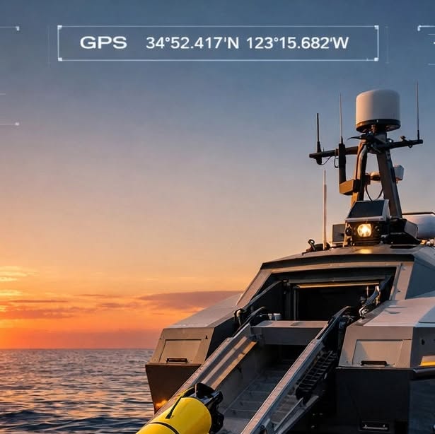
The first autonomous launch of an underwater glider from an uncrewed surface vessel (USV) marks a pivotal step in ocean observation. It is not merely a technical curiosity; it is a scalable solution that transforms how we acquire real‑time, longitudinal data from the deep ocean. By pairing USVs—capable of sustained, autonomous surface operation—with gliders that traverse thousands of kilometers of water column, we create a self‑sufficient monitoring network that delivers calibrated, peer‑reviewed measurements of temperature, salinity, and chemistry without risking human crews or expending expensive vessel time. This partnership exemplifies the integrated data ecosystem that World Data Ocean champions: a system where hardware, software, and science converge to produce validated, actionable intelligence for climate stewardship.
The significance of this milestone extends beyond the novelty of the launch. Historically, deep‑sea observation has been constrained by logistical limitations and high operational costs. Deploying manned research vessels to collect data at depths of several kilometers involves weeks of preparation, significant fuel consumption, and exposure to hazardous conditions. In contrast, the USV‑glider pair can operate unattended for months, sampling in remote basins where current vessels cannot reach safely or economically. This capability unlocks a new era of persistent ocean monitoring, enabling scientists to capture transient events—such as eddies, upwellings, or rapid temperature shifts—that would otherwise evade detection. The data harvested are not only robust but also contextualized by real‑time surface observations from the USV, allowing for integrated analyses that bridge the gap between surface meteorology and deep‑water dynamics.
Moreover, this autonomous system dovetails with the broader objectives of the 30 × 30 initiative, which aims to protect 30 % of the ocean by 2030. As 30x30 means protecting 30% of the ocean by 2030. The goal is clear. The bottleneck is not ambition, it’s coverage: data, we see that comprehensive, high‑resolution data are essential for defining protection boundaries, monitoring compliance, and assessing ecosystem responses. The USV‑glider network can furnish the granular, real‑time indicators needed to refine these management plans, ensuring that policy decisions are grounded in empirically measured ocean health. Additionally, the technology aligns with the blue economy’s demand for sustainable resource management; fisheries, shipping, and coastal development all rely on accurate, timely oceanographic information to mitigate risks and optimize operations.
The broader scientific community will also benefit from this advance. Longitudinal studies that track ocean temperature trends, salinity gradients, and chemical fluxes over years are foundational to climate models and predictive analytics. Traditionally, such studies have suffered from data gaps, especially in the abyssal zones. Autonomous gliders, guided by USVs, can repeatedly sample the same transects, building a continuous record that is both spatially comprehensive and temporally dense. This dataset will feed into global ocean models, improving their fidelity and enabling more precise projections of sea‑level rise, nutrient cycling, and biogeochemical feedbacks. By lowering the barrier to access these deep‑sea environments, we also democratize research, allowing institutions with limited funding to contribute to and benefit from high‑quality ocean data.
Looking ahead, the integration of USVs and gliders opens pathways for further innovation. Future iterations could incorporate additional sensor suites—such as autonomous sediment samplers, acoustic imaging, or autonomous sampling buoys—to capture a fuller picture of ocean health. Coupling these platforms with machine‑learning algorithms for anomaly detection could trigger real‑time alerts for events like harmful algal blooms or oil spills, providing a proactive tool for environmental protection. The question that emerges is how quickly the global research community can adopt and scale this technology to cover the remaining data deserts of the world’s oceans. If we can answer that, we will not only meet the urgent demands of climate policy but also honor our collective responsibility to steward the blue planet with precision, purpose, and persistence.
Read on the original site
Open the publisher's page for the full experience
Related Articles
- Imagine a team of scientists that never sleeps, doesn't get seasick, and explores the deepest corners of our blue planet...Imagine a team of scientists that never sleeps, doesn't get seasick, and explores the deepest corners of our blue planet simultaneously. That’s the reality of autonomous teams in marine science today. We’re moving beyond single-drone missions to a multi-layered future. Imagine a sleek surface vessel (USV) acting as a mobile hub, launching a fleet of underwater gliders to map the seafloor while aerial drones scan from above. It’s like a synchronized orchestra of ocean technology. At World Data Ocean, our job is to make sense of this "symphony." Processing data from multiple sources: motherships, gliders, and sub-surface sensors: requires high-tech integration to turn raw signals into validated ocean intelligence. By using these autonomous teams, we’re getting a higher resolution of our oceans than ever before, in real-time. It’s not just about the robots; it’s about the integrated data ecosystem that drives better stewardship of our waters. The ocean is vast, but with a team like this, it’s starting to feel a lot more connected. #OceanTech #AutonomousSystems #MarineScience #WorldDataOcean
- The future of marine research is looking a lot quieter, cleaner, and smarter. At World Data Ocean, we're watching the tr...The future of marine research is looking a lot quieter, cleaner, and smarter. At World Data Ocean, we're watching the transition from traditional survey ships to autonomous robotic fleets in real-time. Through our Ocean Infinity Operations, these sleek Uncrewed Surface Vessels (USVs) are revolutionizing how we collect data across huge stretches of the open sea. Why is this a massive win? For one, it’s about stewardship. These fleets significantly slash carbon emissions compared to traditional vessels. But it’s also about the science. By integrating AI and autonomous tech, we’re capturing ocean intelligence with a level of accuracy and scale that was once impossible. We’re moving from orbit to the ocean floor, ensuring every byte of data is validated and ready to drive real change. The future of marine surveys isn't just coming: it’s already out there, working 24/7. #MarineInnovation #OceanData #SustainableTech #AutonomousFleets
- From solo ships to robotic swarms: the way we explore the ocean is fundamentally changing. Decades of ocean science reli...From solo ships to robotic swarms: the way we explore the ocean is fundamentally changing. Decades of ocean science relied on a single research vessel at a single point in time. Today, through our Ocean Infinity Operations, we’re witnessing a transition to autonomous robotic fleets. These swarms work in unison, providing a coordinated, real-time data integration that was previously impossible. This shift means we can now map larger areas faster and monitor environmental indicators with validated, empirical accuracy. Instead of a single snapshot, we get a living data ecosystem, allowing researchers and scientists to make more informed decisions for our planet’s future. Whether it's tracking climate indicators or mapping uncharted seafloors, the future is collaborative, autonomous, and data-driven. This is part of our Weekly Ocean Data & Innovation Highlights. Stay tuned as we continue to explore the technologies protecting our blue planet. #OceanData #Robotics #OceanExploration #MarineScience
- Imagine shrinking a whole marine chemistry lab down to the size of your thumb. That’s exactly what’s happening with "Lab...Imagine shrinking a whole marine chemistry lab down to the size of your thumb. That’s exactly what’s happening with "Lab-on-a-Chip" (LoC) technology, and it’s a total game-changer for oceanography. Traditionally, gathering high-quality chemical and biological data meant expensive ship time and manual sampling. Now, these miniaturized, autonomous sensors can be integrated directly into ocean gliders and buoys. They measure everything from pH and nutrients to trace metals in real-time, even in the most remote corners of our blue planet. At World Data Ocean, we’re obsessed with this kind of innovation. By leveraging validated micro-tech, we’re able to provide deeper, more frequent ocean intelligence than ever before. It’s not just about collecting more data: it’s about having smarter, more accessible tools that help us understand and protect our seas "from orbit to ocean floor." The future of ocean science is small, smart, and incredibly powerful. #OceanTech #BlueEconomy #MarineScience #Innovation