NOAA
World Data Ocean keeps NOAA in one place: 22 stories so far. The section currently leads with “Simulate coral bleaching in real time with a free NOAA-powered 3D reef”, “Measured sea level rise validated across decades of ocean data”, and “Ocean's early warnings grow urgent as climate signals accelerate”. A single summer heatwave can transform a vibrant reef into a graveyard. Measured sea level rise, validated across decades of ocean data, tells a clear story. A Global Hub for Ocean Intelligence 4 World Data Ocean is a centralized digital platform where researchers, scientists, and ocean enthusiasts converge to… The list below is every NOAA story on World Data Ocean, newest first.
Simulate coral bleaching in real time with a free NOAA-powered 3D reef
A single summer heatwave can transform a vibrant reef into a graveyard. One builder, moved by witnessing bleached coral on the Great Barrier Reef in 2019, created a free 3D simulation where you set the temperature and watch each coral species bleach, recover, or die according to its own validated heat tolerance. This is empirical, interactive ocean intelligence. For another look at citizen science in action, see our piece on a browser game that turns seahorse identification into a research tool.

Measured sea level rise validated across decades of ocean data
Measured sea level rise, validated across decades of ocean data, tells a clear story. Seasonal estimates from Church and White (2011) align with the University of Hawaii's Fast Delivery data, both showing change in millimeters against the 1993-2008 average. This is empirical, peer-reviewed evidence of a measurable climate signal. For deeper context, our coverage of 2025 Temperature Anomalies reveals how these climate indicators connect. Understanding drives protection.
Ocean's early warnings grow urgent as climate signals accelerate
The North Pacific's surface has warmed four times faster than the global average, a signal we can no longer ignore. Ocean intelligence now shows climate indicators moving beyond modeled projections. These are not abstract trends; they are measurable, real-time shifts in a system we depend on. Understanding drives protection. Our related piece on ECCO‑Darwin's first multi‑decadal global ocean CO₂ flux estimates offers another calibrated look at how fast this change is actually happening.

From surface to seafloor, a calibrated global map of microplastic drift
From surface to seafloor, this calibrated global map of microplastic drift transforms scattered data into measurable ocean intelligence. It is empirical, peer-reviewed, and urgently needed. Understanding where plastics accumulate, and where they travel, is the first step toward action. For deeper context on the sources feeding this crisis, see our related coverage of how more than 1,000 rivers drive 80% of ocean plastic emissions. Protection begins with precision.
Saildrone delivers first-ever hurricane interior video from the ocean surface
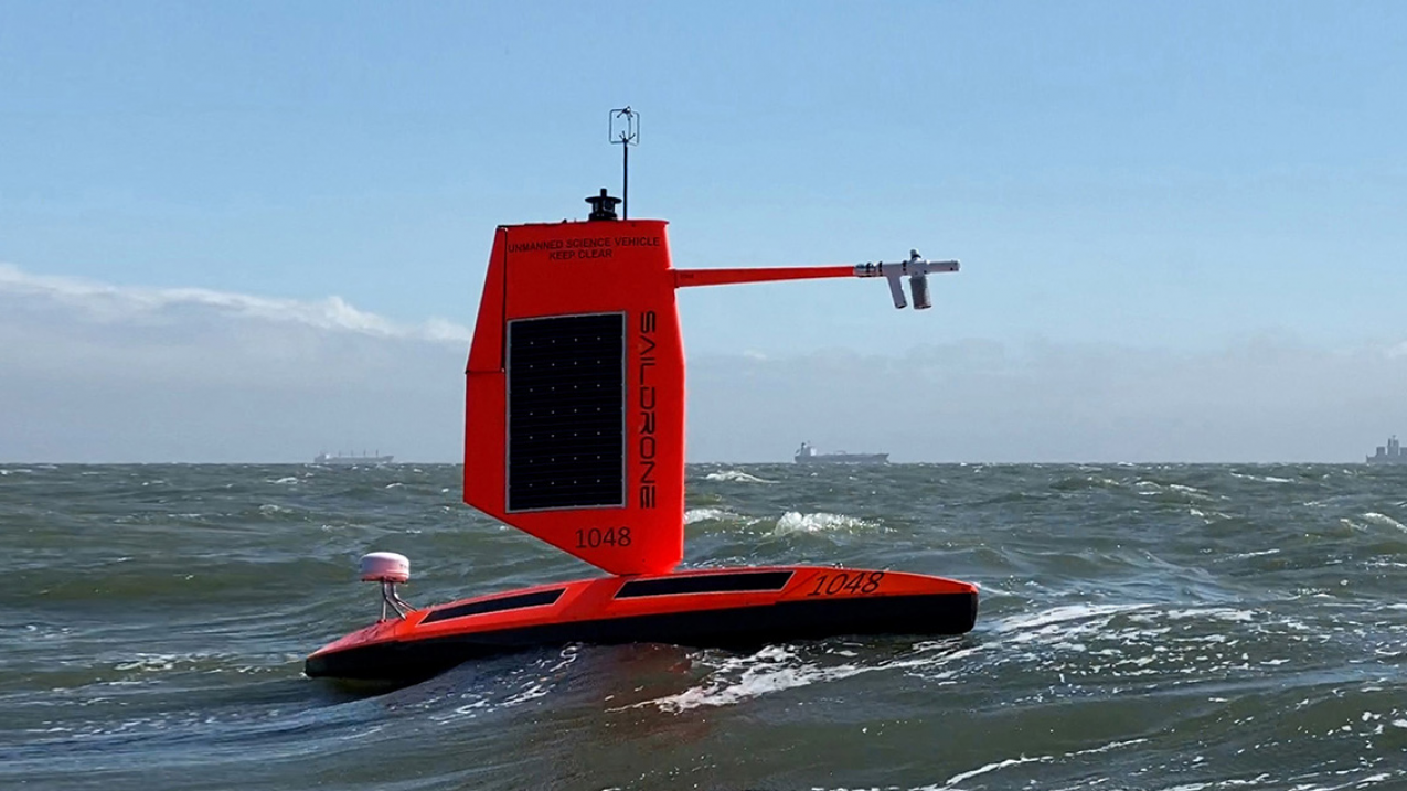
For the first time, a Saildrone has captured video from inside a hurricane at the ocean surface, offering a new window into the forces that drive these storms. This is not abstract data; it is direct, empirical observation from a place we have never seen. Understanding drives protection, and this ocean intelligence is a measurable leap forward. For deeper context on the conditions fueling such storms, see our coverage of August's record-breaking ocean heat readings.

Calibrated search reveals ocean intelligence from seafloor to surface
From seafloor to surface, a calibrated search reveals ocean intelligence that is both validated and measurable, this is what NOAA's new discovery platform delivers. It transforms raw depth data into integrated, real-time insights we can trust. Understanding drives protection, and this tool makes that possible. For deeper context on why such calibrated monitoring matters, read our coverage of the proposed US cuts that risk leaving the world "flying blind."

Empirical ocean data now calibrated for classroom discovery
Empirical ocean data, validated, calibrated, and peer-reviewed, is now ready for classroom discovery. NOAA's new classroom-ready resources bring real-time climate indicators and integrated data ecosystems directly to students, transforming raw ocean intelligence into measurable learning. This is not simplified science; it is authentic data made accessible. Understanding drives protection, and these tools equip the next generation to act. For deeper context on how data refines ocean stewardship, explore "From orbit to ocean floor, data refines ocean stewardship" on our site.

Decades of Atlantic circulation data reveal measurable climate indicators
Decades of Atlantic circulation data now offer something the field has long needed: measurable, validated climate indicators. This isn't anecdotal observation, it's empirical, longitudinal evidence of change. Understanding drives protection, and this dataset from NOAA gives researchers and policymakers a calibrated baseline to measure what comes next. For deeper context on the ocean's thermohaline structure, our related work on a validated global atlas from WOA18 connects the dots between surface signals and the deep currents that drive them.

The ocean measured, validated, and shared through integrated global data
The ocean measured, validated, and shared through integrated global data, this is the mission behind World Ocean Database Profiles the Ocean at ncei.noaa.gov. It transforms scattered observations into a single, empirical foundation for climate indicators. Understanding drives protection. For deeper context on making this data ecosystem sustainable, see our related article, "Calibrating our ocean intelligence for a sustainable data ecosystem." From orbit to ocean floor, we build the integrated data ecosystem that underpins real-time ocean intelligence.

Small ocean drone returns validated data from inside Category 5 hurricane
A small ocean drone has returned validated data from inside a Category 5 hurricane, a world first for NOAA/AOML. This is empirical ocean intelligence at its most daring. Measuring what was previously unmeasurable, the drone's real-time readings from the storm's core will sharpen our climate indicators and refine the models that guide marine stewardship. For deeper context on how such data tracks progress, see our related analysis, "Ocean intelligence measures our progress toward sustainable marine stewardship."

Ocean data expands from measured depths to validated insights
From orbit to ocean floor, the National Centers for Environmental Information (NCEI) transforms measured depths into validated, peer-reviewed insights. This expanding ocean of data is our most calibrated window into planetary change. Understanding drives protection. For deeper context on how these long-term records reveal accelerating shifts, see our related analysis, "Decades of Atlantic circulation data reveal measurable climate indicators." The empirical story is clear: what we measure, we can protect.

Refining Global Ocean Intelligence with New Empirical Climatologies
New empirical climatologies have been added to the World Ocean Atlas, refining our understanding of ocean state with validated, measurable data. This update strengthens the integrated data ecosystem that underpins global ocean intelligence. Those tracking marine debris will find a natural companion in our recent mapping of microplastic drift from surface to seafloor. Understanding drives protection, and these calibrated baselines give us the precision we need to act.

Unidentified Skeleton on Puerto Rico Coast Stumps Local Experts
An eight-inch skull and vertebrae nearly the size of your palm, pulled from the same stretch of Puerto Rico's west coast, have left even the pros guessing. The fishermen on the beach were stumped. So was the NOAA contact who saw the photos. Google's image search suggests a drum fish, but the Caribbean species we know run small. This was dense, heavy, and undeniably out of place. Sometimes the ocean reminds us how much remains unmeasured.

Calibrated ocean intelligence, now within reach through integrated data discovery
Calibrated ocean intelligence is no longer a distant ambition; it is a practical tool for researchers and policymakers alike. NOAA's National Centers for Environmental Information brings that capability into focus, offering integrated data discovery that turns raw observations into actionable insight. This is the kind of clarity that strengthens our shared stewardship of the seas. For those tracking how marine environments shift, from deep-sea mapping to unexpected benthic finds, our coverage of the Port Phillip Bay debate adds a useful layer of context.
Cultivating a Young Oceanographer: Resources for Budding Marine Scientists
A seven-year-old with a career plan and a housing strategy is a force of nature. This family is asking the right questions, seeking direction without dimming her ambition. The request for open-source lectures and NOAA contacts shows a commitment to real, validated learning over fluff. That focus on empirical resources is exactly what builds a foundation. For those ready to connect their passion to the broader picture, our piece on bridging data gaps with citizen science offers a practical entry point.
Real-Time Seafloor Data: Current Availability and Coverage Insights
The question of real-time seafloor data cuts to the heart of how we share ocean intelligence. The user is right: NCEI archives raw and processed multibeam surveys, but post-processing creates a bottleneck, delaying public access. Archive-only is the current reality for most feeds, though some research vessels stream bathymetry live via satellite. Coverage skews toward U.S. EEZ and coastal priorities, not broad global reach. That gap matters. For those tracking plankton dynamics or other fine-scale phenomena, timing is everything.
Ocean Intelligence: Measuring Change in the Underwater World.
The ocean's most consequential changes often occur beyond the reach of sunlight, yet measuring them demands precision that matches the depths. NOAA's National Centers for Environmental Information anchors this effort, turning raw underwater data into validated, climate-ready intelligence. That rigor matters; without it, we are guessing at the pulse of a system that regulates everything. For those tracking how marine infrastructure evolves alongside such monitoring, our piece on Van Oord's new fallpipe vessels, *Vindnes* and *Vestnes*, offers a fitting glimpse of industrial adaptation.
Real-Time Ocean Data Fuels Climate Insights Through GLODAP.
The ocean speaks in data, and GLODAP ensures we are listening. By integrating real-time observations with the rigorous standards of peer-reviewed science, this initiative turns raw measurements into validated climate indicators. We see this as a vital step toward actionable ocean intelligence, proving that what happens beneath the surface shapes our global climate reality. It is a clear, empirical call for collaborative stewardship, and for those charting a career in this field, our piece on international Master's programs offers a practical next step.
Integrated Ocean Data: Empowering Solutions for a Changing World.
The ocean remains the planet's least observed system, yet it regulates everything. The Integrated Ocean Data initiative confronts this gap directly, uniting fragmented observations into a cohesive, actionable framework. We see this as the right kind of urgency: not alarmist, but empirical. By prioritizing calibrated, real-time information, this effort moves beyond data collection toward genuine ocean intelligence. For those tracking parallel developments, our coverage of the Indian Ocean's new subsea cables illustrates the same principle: connectivity is reshaping how we monitor and protect these waters.
Ocean Data: Measuring Change, Informing Action.
A bucket of seawater seems simple. Yet that single sample carries a measurable story of temperature, chemistry, and change. Ocean Data: Measuring Change, Informing Action explores how NOAA's NCEI turns such raw observations into calibrated, peer-reviewed intelligence. We appreciate this grounding in empirical evidence; it is the difference between opinion and insight. For those inspired to explore further, our related piece, "Cultivating a Young Oceanographer," offers pathways for the next generation of researchers.
Measuring the Ocean's Vital Role in Carbon Capture.
The ocean breathes, and in that breath, it pulls carbon from the sky into the deep. NOAA's National Centers for Environmental Information is quantifying that exchange with calibrated, peer-reviewed precision, turning a vast abstraction into measurable climate indicators. We find this work essential because it grounds our understanding of the planet in empirical reality. For those inspired to see how this data becomes accessible, our related piece, "Calibrated ocean intelligence, now within reach through integrated data discovery," offers a practical next step.
Ocean Carbon Data Expands, Driving Climate Insights and Stewardship.
Newly released SOCAT and GLODAP datasets give researchers a sharper read on ocean carbon, and that clarity matters. NOAA's latest update strengthens our ability to track climate indicators with empirical rigor, turning scattered observations into an integrated data ecosystem. This is ocean intelligence in action: measured, validated, and ready to inform stewardship. For those exploring how such calibrated data flows into broader discovery efforts, our related piece on integrated data discovery offers a useful next step. The science is solid, and the timing feels right.