remote sensing
33 stories filed under remote sensing on World Data Ocean. The newest of them: “Oil Spill Expands Near Oman, Linked to Russian-Flagged Tanker.”, “Advancing Plastic Litter Mapping with AI-Powered Hyperspectral Data Analysis”, and “Canopy Views: Do Kelp Forest Assessments Accurately Reflect Underlying Structure?”. The Caroline Bezengi, laden with Russian crude from Novorossiysk, now trails an expanding oil slick near Oman's coast. Hyperspectral imaging from UAVs has long promised precise plastic litter mapping, but variability between flights has kept that promise out of reach. A Global Hub for Ocean Intelligence 4 World Data Ocean is a centralized digital platform where researchers, scientists, and ocean enthusiasts converge to… The list below is every remote sensing story on World Data Ocean, newest first.

Oil Spill Expands Near Oman, Linked to Russian-Flagged Tanker.
The Caroline Bezengi, laden with Russian crude from Novorossiysk, now trails an expanding oil slick near Oman's coast. The spill's link to a vessel at the heart of sanctioned trade routes is no coincidence; it is a measurable consequence of geopolitical pressure applied at sea. This incident underscores how quickly environmental risk follows maritime decision-making. For context on the broader pattern, our related piece, "Russia Calibrates Export Revenue for Northern Sea Route Icebreaker Fleet," examines Moscow's ongoing calculations.

Advancing Plastic Litter Mapping with AI-Powered Hyperspectral Data Analysis
Hyperspectral imaging from UAVs has long promised precise plastic litter mapping, but variability between flights has kept that promise out of reach. This study confronts the problem directly, standardizing each cube's spectral statistics before segmentation to reduce acquisition-specific bias. The result is a compact ConvNeXt V2-based U-Net that lifts mean IoU from 49.0% to 64.5%, with gains most pronounced under overexposure and background confusion. It is a practical step toward reliable cross-flight monitoring.
Canopy Views: Do Kelp Forest Assessments Accurately Reflect Underlying Structure?
A 23-year monthly timeseries from southern California reveals that floating kelp canopies capture only 12-38% of giant kelp's total biomass, depending on site and season. This gap matters because surface assessments routinely inform management decisions, yet they often miss high subsurface biomass entirely. The canopy also proves a weak predictor of plant density, size, or morphology for most of the year. Understanding these limits is essential before surface data guides conservation.
Charting a Course: MSc Thesis Opportunities in Hydrography and Geoinformatics
A Master's thesis in hydrography is more than an academic requirement; it is a chance to contribute directly to how we measure and protect the marine environment. The student's focus on practical applications and collaboration with research institutes aligns well with the field's need for integrated, real-time data. For those exploring similar paths, the related article "Calibrated ocean intelligence, now within reach through integrated data discovery" offers a useful perspective on where the data ecosystem is heading.
Data-Driven Ocean Stewardship: Balancing Fisheries, Aquaculture, and Future Resources.
The science of ocean stewardship is only as strong as the data beneath it. Marine fisheries, aquaculture, and living resources demand frank, unbiased evidence to navigate climate adaptation, shifting species, and food security pressures. Artificial reefs and sustainable feed systems offer measurable pathways forward, yet fragmented governance and regulatory uncertainty remain stubborn barriers. We need integrated, peer-reviewed approaches to translate complexity into actionable policy. As we explore the next decade, the work must be transparent and reproducible.

Gravity-1 Rocket Deployment: Validating Ocean-Based Satellite Launches
On Wednesday at 10:54 am, ORIENSPACE launched its Gravity-1 rocket from a ship in the East China Sea, marking a significant step in validating ocean-based satellite launches. This approach leverages the sea's vastness for greater flexibility, and the successful deployment underscores the growing maturity of maritime space operations. It's a practical demonstration of how integrated platforms can expand access to orbit. For more on how marine infrastructure supports broader data goals, see our coverage of integrated subsea cables enhancing transmission across the Indian Ocean.
Data-Driven Ocean Insights: Tracking Biodiversity with New Technologies
Machine learning, citizen science, and environmental DNA are no longer abstract tools; they are the backbone of a new era in marine observation. This research, presented at a June 2025 summer school, shows how these technologies, from computer vision to autonomous vehicles, are making biodiversity tracking more precise and more inclusive. It is a practical path toward understanding our oceans, not a theoretical one.
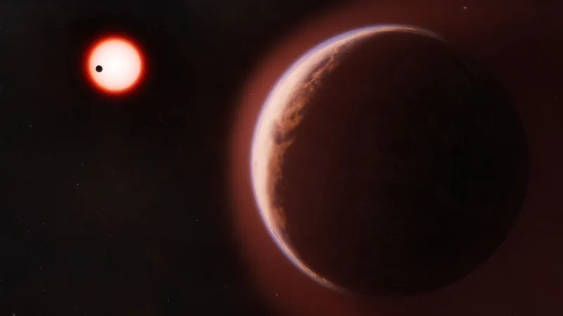
Helium Atmosphere Hints at Potential for Life on Rocky Exoplanet
A helium atmosphere on a rocky exoplanet is a rare and telling signal. Astronomers detected this tenuous envelope around a world beyond our solar system, and while it is not direct evidence of biology, it sharpens the search for life where it matters most. The finding validates our ability to probe distant atmospheres with increasing precision.
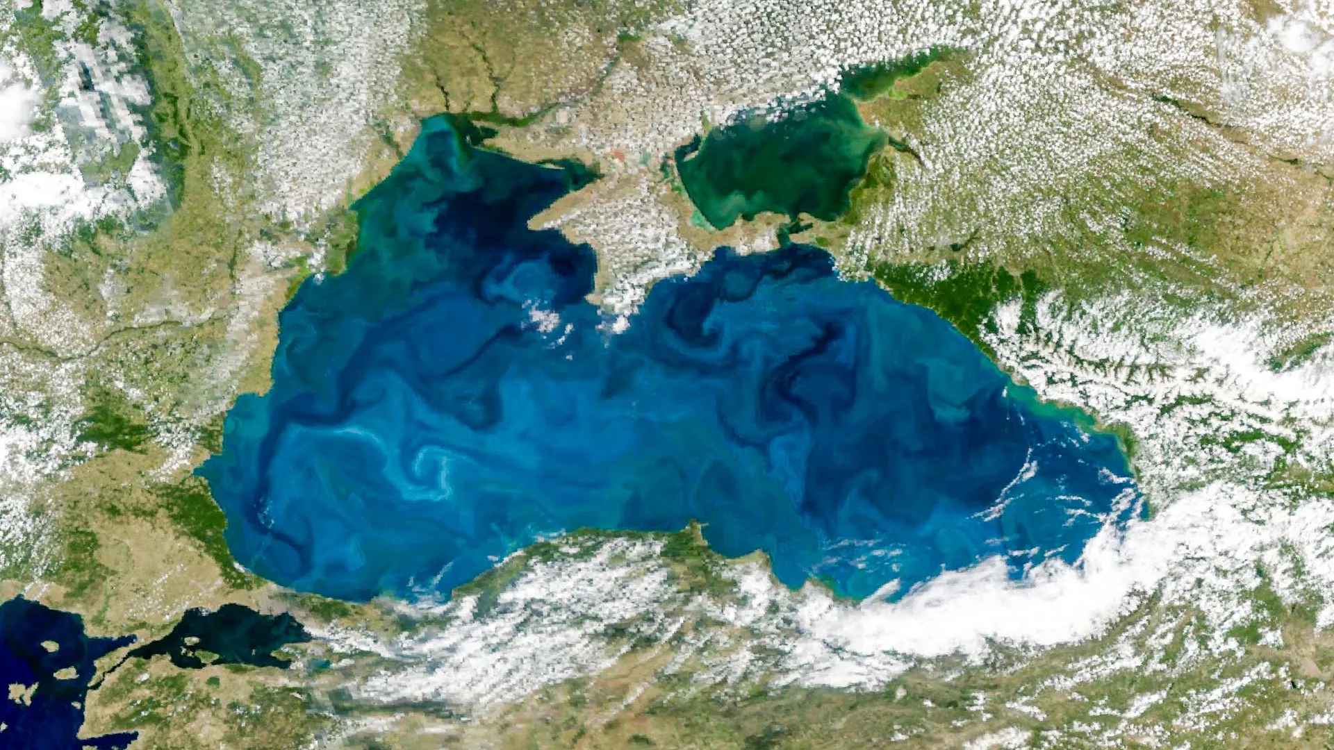
Black Sea Bloom: Satellite Data Reveals Turquoise Waters from Space
From orbit, the Black Sea has turned turquoise. NASA's PACE satellite captured the annual phytoplankton bloom, its reflective coccolithophore shells brightening the water enough to be seen from space. An astronaut on the International Space Station also photographed the bloom threading through the Bosphorus, where swirling currents reveal its reach. It is a striking reminder that ocean intelligence begins with observation, and that such calibrated data is essential for tracking the health of our shared seas.