ocean plastic
4 stories filed under ocean plastic on World Data Ocean. The newest of them: “Mapping the 2019 Flow of Plastic Waste into Our Ocean”, “Largest-ever survey of the Great Pacific Garbage Patch yields calibrated data”, and “Satellite data reveals measurable pathways of ocean plastic pollution”. In 2019, rivers carried the overwhelming share of plastic waste into our ocean, a measurable, empirical signal we cannot ignore. The most extensive analysis ever conducted of the Great Pacific Garbage Patch has yielded calibrated, empirical data on the world's largest ocean plastic accumulation, located between Hawaii and California. A Global Hub for Ocean Intelligence 4 World Data Ocean is a centralized digital platform where researchers, scientists, and ocean enthusiasts converge to… The list below is every ocean plastic story on World Data Ocean, newest first.
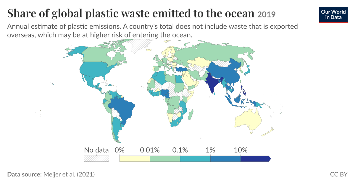
Mapping the 2019 Flow of Plastic Waste into Our Ocean
In 2019, rivers carried the overwhelming share of plastic waste into our ocean, a measurable, empirical signal we cannot ignore. Asia accounts for more than 80% of this flow, a concentrated challenge demanding integrated, global action. Understanding this longitudinal data is the first step toward calibrated solutions. For deeper insight into how these plastics cross borders, see our related study, "Tracking the transboundary flow of plastic waste from high-income nations."
Largest-ever survey of the Great Pacific Garbage Patch yields calibrated data
The most extensive analysis ever conducted of the Great Pacific Garbage Patch has yielded calibrated, empirical data on the world's largest ocean plastic accumulation, located between Hawaii and California. This validated survey by The Ocean Cleanup transforms our understanding from estimates to measurable reality. Understanding drives protection. For deeper context on how plastic reaches these waters, see our related piece, "Pinpointing the 1000 Rivers Driving Plastic to the Ocean."
Satellite data reveals measurable pathways of ocean plastic pollution
Satellite data now reveals measurable pathways of ocean plastic pollution, turning what was once an invisible crisis into a trackable phenomenon. NASA's Earthdata tracking, from orbit to ocean floor, offers empirical, real-time insight into where plastic travels and accumulates. This is ocean intelligence at its most urgent and actionable. Understanding drives protection. For deeper coverage on how integrated data ecosystems map this challenge, see our related piece, "From coast to current: tracking plastic pollution through integrated ocean intelligence."
Tracing ocean plastic to its land-based sources via empirical data
Every river is a potential pipeline. Our latest analysis, grounded in empirical data, traces ocean plastic back to its land-based origins. The evidence is clear: mismanaged waste from coastal populations is the primary driver. This is not guesswork; it is a measurable, validated flow. Understanding this pathway is the first step toward intervention. For deeper insight into where these plastics ultimately settle, see our related piece, "From surface to seafloor, a calibrated global map of microplastic drift.