mapping
World Data Ocean keeps mapping in one place: 12 stories so far. The section currently leads with “From orbit to ocean floor: big data maps the seafloor with precision”, “Open Source Data Charts a Measurable Course for Global Ocean Mapping”, and “A global framework to measure and map the ocean's integrated data ecosystem”. A University of Sydney-led team has integrated satellite altimetry with shipboard sonar data to produce a calibrated, high-resolution map of the global seafloor. A new open-source data framework charts a measurable course for global ocean mapping, turning fragmented observations into a coherent, integrated data ecosystem. A Global Hub for Ocean Intelligence 4 World Data Ocean is a centralized digital platform where researchers, scientists, and ocean enthusiasts converge to… The list below is every mapping story on World Data Ocean, newest first.
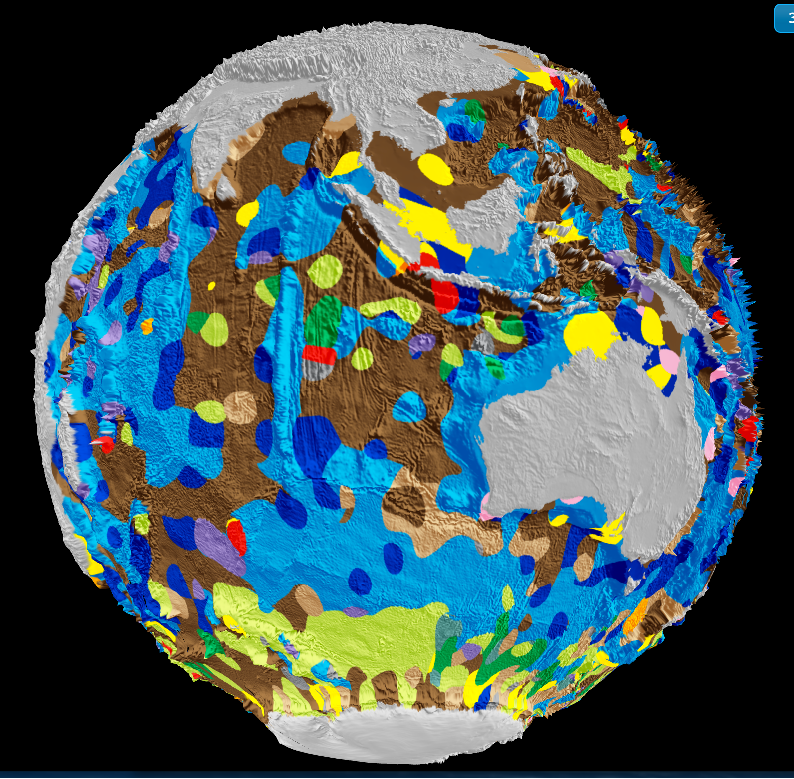
From orbit to ocean floor: big data maps the seafloor with precision
A University of Sydney-led team has integrated satellite altimetry with shipboard sonar data to produce a calibrated, high-resolution map of the global seafloor. This isn't just a sharper image, it's a validated baseline for measuring change. Understanding drives protection. When we can track sediment transport, tectonic activity, and benthic habitat shifts with empirical precision, ocean stewardship becomes measurable. For deeper context on how ocean intelligence reveals system-wide change, see our coverage of the century-long current slowdown.

Open Source Data Charts a Measurable Course for Global Ocean Mapping
A new open-source data framework charts a measurable course for global ocean mapping, turning fragmented observations into a coherent, integrated data ecosystem. This isn't abstract theory, it's a calibrated, peer-reviewed foundation for action. We see this as essential to building ocean intelligence. For a deeper look at how empirical data traces pollution back to its sources, see our related piece, "Tracing ocean plastic to its land-based sources via empirical data." Understanding drives protection.

A global framework to measure and map the ocean's integrated data ecosystem
A single, integrated framework can now measure and map the ocean's data ecosystem with the precision it deserves. International Coordination to Map the World Ocean on ArcGIS StoryMaps establishes a global standard for connecting fragmented marine observations into a validated, real-time ocean intelligence system. This isn't about more data, it's about calibrated, actionable knowledge. For a complementary view of connectivity, explore our related piece on the Spilhaus World Ocean Map in a Square.

From orbit to ocean floor: a calibrated view of marine ecosystems
From orbit to ocean floor, a calibrated view of marine ecosystems now exists. The USGS has mapped the world's ocean ecosystems with empirical precision, integrating satellite data with seafloor observations. This isn't just another dataset, it's a validated, real-time foundation for ocean intelligence. Understanding drives protection. For those tracking sustainable stewardship, our related piece on "Ocean intelligence measures our progress toward sustainable marine stewardship" offers complementary insights into how these measurements translate into measurable action.

Mapping American Samoa's Seabed: An ROV Exploration in 2026
In 2026, a remotely operated vehicle will descend into the waters around American Samoa, mapping the seabed with calibrated precision. This is ocean intelligence at its most tangible: measurable, peer-reviewed, and essential for informed stewardship. We see this as a vital step in building an integrated data ecosystem, one that connects seafloor topography to broader climate indicators. For a deeper look at how marine operations are adapting in challenging regions, explore our coverage of "Mitigating Supply Chain Risk: KPC Enables Ship-to-Ship Transfers."
Hydrographic Surveyors Share Data, Expanding Ocean Intelligence Insights
When hydrographic surveyors share their datasets, they turn individual measurements into a shared foundation for ocean intelligence. This collaborative act strengthens the integrated data ecosystem that informs navigation, climate indicators, and marine policy. We see this as a practical step toward measurable progress. For those tracking how such information shapes regional stability, our related piece on Ukraine's support for India's Black Sea shipping initiative offers useful context. Sharing data is not just transparent; it is how we build a more resilient understanding of our oceans.
Bridging Geography and Oceanography: A Path to Marine Science Research
A Geography undergrad with QGIS skills and a pull toward oceanography is holding a map to a door that's already slightly open. The gap between land-based spatial thinking and marine science is real, but it is not a wall, it's a bridge. Your GIS background is a validated entry point, not a consolation prize. Start with marine-focused QGIS tutorials and coastal data sets; pair them with open-access oceanography courses to build the science vocabulary.

Mapping the Ocean Floor: Geospatial Innovation Drives Global Discovery
The ocean floor remains Earth's least mapped frontier, yet geospatial innovation is closing that gap with measurable precision. This piece from Geography Realm examines how integrated data ecosystems and calibrated technologies are accelerating the effort to complete a global seafloor map. It is a practical, empirical look at a monumental task. For readers tracking maritime infrastructure's role in this work, our coverage of Van Oord's new fallpipe vessels, "Vindnes and Vestnes," offers a fitting complement.
Mapping Ocean Protection: A Global Database for Enhanced Stewardship
Mapping Ocean Protection: A Global Database for Enhanced Stewardship - Navigator - a global database of verified marine protected and managed area regulations and boundaries Nature Protected areas only work when their boundaries are clear and their rules are known. Navigator consolidates verified regulations and spatial data into a single, integrated ecosystem, turning fragmented oversight into measurable ocean intelligence. This is not abstract ambition; it is a practical tool for accountability.
Empowering Ocean Insights: Global Fishing Watch Data Now in ArcGIS.
Global Fishing Watch data is now live in ArcGIS Online and the Living Atlas, bringing validated, real-time ocean intelligence directly into the hands of researchers and policymakers. This integration is a practical step toward measurable stewardship, and we're glad to see it. For those tracking enforcement efforts, our related piece on Maritime Interdictions shows how such tools support security at sea. Understanding drives protection, and this data ecosystem makes that understanding more accessible than ever.
Mapping American Samoa's Depths: An Exploration of Ocean Intelligence.
Beneath the waves of American Samoa lies a terrain as uncharted as it is vital, and this latest expedition turns raw data into actionable insight. We're encouraged by how this work transforms seabed mapping into a tool for stewardship, not just discovery. It's precise, purposeful, and exactly the kind of empirical effort our shared ocean future demands.
Mapping American Samoa’s Depths: An Exploration with Advanced Underwater Technology
American Samoa's waters hold more than meets the eye, and this expedition proves it. Mapping these depths with advanced underwater technology reveals a seabed shaped by volcanic force and time, a place where bathymetry becomes biography. We find this work compelling because it turns raw data into actionable ocean intelligence, grounding conservation in measurable truth. For those seeking the broader picture, our related article, "Mapping American Samoa's Seabed: An ROV Exploration in 2026," expands on the tools behind this effort.